PacIOOS Water Quality Sensor Partnership Program Enhances Maui Nui Marine Resource Council’s Water Quality Monitoring in Māʻalaea Harbor
/
MĀʻALAEA, HI – Maui Nui Marine Resource Council’s ocean water quality monitoring efforts in Māʻalaea Harbor are being helped by a new underwater data sensor that the organization has borrowed through the Pacific Islands Ocean Observing System (PacIOOS) Water Quality Sensor Partnership Program. The new data sensor collects data every five minutes on water temperature, salinity, turbidity, chlorophyll and ocean depth.
The PacIOOS program supports scientists and natural resource managers to collect water quality data in order to inform research, conservation, planning, and resource management projects in the U.S. Pacific Islands region. The data sensor is owned and maintained by PacIOOS under the supervision of Dr. Margaret McManus, Chairwoman of the Department of Oceanography at the University of Hawai‘i at Mānoa.
“We are grateful to PacIOOS for the use of this data sensor that will help us learn more about the effects of tides, swell, rain events, and runoff on water quality within Māʻalaea Harbor and to monitor water quality variability over time,” reports Amy Hodges, Programs and Operations Manager at Maui Nui Marine Resource Council.
Mounted 1 or 2 meters below the ocean’s surface, the sensor package is relocated by divers from Maui Nui Marine Resource team to a new site within the harbor about once per month. The sensor package was installed in 2020 and is scheduled to be used in Māʻalaea Harbor through 2021.
The PacIOOS data sensor will help guide Maui Nui Marine Resource Council as it implements its watershed management plan, which aims to reduce sediment and pollutants in Māʻalaea Bay and its harbor. Professor Margaret McManus
“In recent decades, declining ocean water quality has led to significant deterioration of Māʻalaea Bay’s reefs,” says Hodges. “Monitoring by the community-based program Hui O Ka Wai Ola — which was co-founded and is co-managed by Maui Nui Marine Resource Council, The Nature Conservancy and West Maui Ridge to Reef Initiative — using ocean water samples grabbed from the ocean edge has shown turbidity (sediment) and excessive nitrogen as primary causes of impaired water quality.”
Maui Nui Marine Resource Council’s staff also assist with gathering ocean water quality “grab samples” from the shore. All combined, the Hui O Ka Wai Ola sampling and the MNMRC staff grab sampling results in data from 5-10 sites every three weeks in Māʻalaea Harbor.
Maui Nui Marine Resource Council has also been using a Manta data sonde, purchased with a grant from LUSH cosmetics, to gather water quality data in the Harbor. The sonde is towed behind a kayak and records real time data as it is pulled through varying depths through the water.
The organization has also been testing the nitrogen isotope ratios (δ15N values) in macroalgae (limu) tissue to determine the possible sources of nitrogen pollution in the harbor and the bay. Other ongoing testing in Māʻalaea Bay conducted by MNMRC includes current drift analysis studies, underwater coral cover and fish transects, and stormwater sampling.
To address Māʻalaea’s sediment issues, MNMRC is working to improve stormwater management in the 4,000 acre Pohakea watershed adjoining Mā‘alaea Bay. In 2018, MNMRC commissioned Maui Environmental Consulting (MEC) to create the Pohakea Stormwater Management Plan following meetings with Hawai‘i Division of Forestry and Wildlife (DOFAW), Māʻalaea Village Association, Maui Ocean Center and other stakeholders.
MNMRC has been enacting the priorities in this plan. In 2020, MNMRC installed firebreaks in Pohakea watershed to suppress frequent wildfires that occur in this windy, dry region, causing loss of vegetative cover that helps hold soil in place and prevents erosion. Partners included DOFAW, Maui Electric Co. and Goodfellow Bros. Inc.
MNMRC and Maui Environmental Consulting began monitoring headcuts (erosional features) in 2020 to quantify soil loss at four of the most severely eroded sites in the Pohakea watershed nearest the harbor. Their monitoring showed a loss of an estimated 64,050 pounds, or 32 tons, of soil from just two head cut locations in a single moderate rainstorm in January 2021. The lost soil was likely transported via culverts directly into the ocean, contributing to a severe brown water event in Māʻalaea Bay. MNMRC is now working to obtain funding to work with Maui Environmental Consulting and Goodfellow Bros. to repair two of the most severe head cut locations to reduce the sediment runoff.
Maui Nui Marine Resource Council launched an oyster bioremediation project in Māʻalaea Bay in 2020 to utilize caged oysters as a natural method of water filtration. A single oyster can filter up to 50 gallons of ocean water per day, removing sediment and pollutants. During 2020, MNMRC installed more than 10,000 oysters and conducts periodic monitoring to assess their growth rates and health. Data from the PacIOOS data sensor will help measure changing ocean water quality conditions in response to the oyster program.
“The progress of our projects to clean up Māʻalaea Bay’s water quality will be measured by resulting data from the PacIOOS data sensor and our other monitoring methods,” says Hodges. “We to see evidence of improved ocean water quality, through reductions in sediment and excess nitrogen, an essential step in restoring coral cover and reef health in Māʻalaea Harbor and in the bay.”
To learn more about the PacIOOS Water Quality Sensor Partnership Program and view data, visit https://www.pacioos.hawaii.edu/water/sensor-maalaea/#about.
Founded in 2007, Maui Nui Marine Resource Council is a nonprofit 501(c)(3) organization working for clean ocean water, healthy coral reefs and abundant native fish for the islands of Maui County. To learn more, visit www.mauireefs.org.
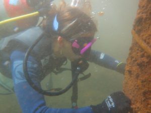
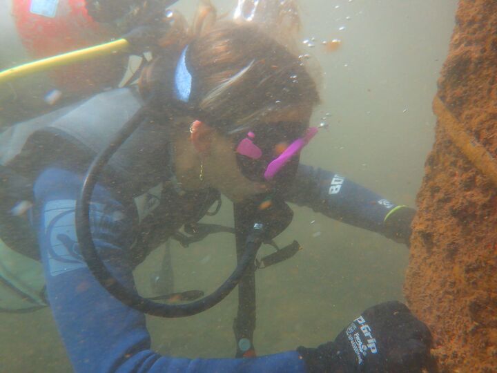
CAPTION: Maui Nui Marine Resource Council’s Grace Silver helps to prepare a site in Mā’alaea Harbor for the data sensor on loan from PacIOOS.