Posts

PacIOOS Water Quality Sensor Partnership Program Enhances Maui Nui Marine Resource Council’s Water Quality Monitoring in Māʻalaea Harbor

in /by


MĀʻALAEA, HI – Maui Nui Marine Resource Council’s ocean water quality monitoring efforts in Māʻalaea Harbor are being helped by a new underwater data sensor that the organization has borrowed through the Pacific Islands Ocean Observing System (PacIOOS) Water Quality Sensor Partnership Program. The new data sensor collects data every five minutes on water temperature, salinity, turbidity, chlorophyll and ocean depth.

The PacIOOS program supports scientists and natural resource managers to collect water quality data in order to inform research, conservation, planning, and resource management projects in the U.S. Pacific Islands region. The data sensor is owned and maintained by PacIOOS under the supervision of Dr. Margaret McManus, Chairwoman of the Department of Oceanography at the University of Hawai‘i at Mānoa.

“We are grateful to PacIOOS for the use of this data sensor that will help us learn more about the effects of tides, swell, rain events, and runoff on water quality within Māʻalaea Harbor and to monitor water quality variability over time,” reports Amy Hodges, Programs and Operations Manager at Maui Nui Marine Resource Council.

Mounted 1 or 2 meters below the ocean’s surface, the sensor package is relocated by divers from Maui Nui Marine Resource team to a new site within the harbor about once per month. The sensor package was installed in 2020 and is scheduled to be used in Māʻalaea Harbor through 2021.

The PacIOOS data sensor will help guide Maui Nui Marine Resource Council as it implements its watershed management plan, which aims to reduce sediment and pollutants in Māʻalaea Bay and its harbor. Professor Margaret McManus

“In recent decades, declining ocean water quality has led to significant deterioration of Māʻalaea Bay’s reefs,” says Hodges. “Monitoring by the community-based program Hui O Ka Wai Ola — which was co-founded and is co-managed by Maui Nui Marine Resource Council, The Nature Conservancy and West Maui Ridge to Reef Initiative —  using ocean water samples grabbed from the ocean edge has shown turbidity (sediment) and excessive nitrogen as primary causes of impaired water quality.”

Maui Nui Marine Resource Council’s staff also assist with gathering ocean water quality “grab samples” from the shore. All combined, the Hui O Ka Wai Ola sampling and the MNMRC staff grab sampling results in data from 5-10 sites every three weeks in Māʻalaea Harbor.

Maui Nui Marine Resource Council has also been using a Manta data sonde, purchased with a grant from LUSH cosmetics, to gather water quality data in the Harbor. The sonde is towed behind a kayak and records real time data as it is pulled through varying depths through the water.

The organization has also been testing the nitrogen isotope ratios (δ15N values) in macroalgae (limu) tissue to determine the possible sources of nitrogen pollution in the harbor and the bay. Other ongoing testing in Māʻalaea Bay conducted by MNMRC includes current drift analysis studies, underwater coral cover and fish transects, and stormwater sampling.

To address Māʻalaea’s sediment issues, MNMRC is working to improve stormwater management in the 4,000 acre Pohakea watershed adjoining Mā‘alaea Bay. In 2018, MNMRC commissioned Maui Environmental Consulting (MEC) to create the Pohakea Stormwater Management Plan following meetings with Hawai‘i Division of Forestry and Wildlife (DOFAW), Māʻalaea Village Association, Maui Ocean Center and other stakeholders.

MNMRC has been enacting the priorities in this plan. In 2020, MNMRC installed firebreaks in Pohakea watershed to suppress frequent wildfires that occur in this windy, dry region, causing loss of vegetative cover that helps hold soil in place and prevents erosion. Partners included DOFAW, Maui Electric Co. and Goodfellow Bros. Inc.

MNMRC and Maui Environmental Consulting began monitoring headcuts (erosional features) in 2020 to quantify soil loss at four of the most severely eroded sites in the Pohakea watershed nearest the harbor. Their monitoring showed a loss of an estimated 64,050 pounds, or 32 tons, of soil from just two head cut locations in a single moderate rainstorm in January 2021. The lost soil was likely transported via culverts directly into the ocean, contributing to a severe brown water event in Māʻalaea Bay.  MNMRC is now working to obtain funding to work with Maui Environmental Consulting and Goodfellow Bros. to repair two of the most severe head cut locations to reduce the sediment runoff.

Maui Nui Marine Resource Council launched an oyster bioremediation project in Māʻalaea Bay in 2020 to utilize caged oysters as a natural method of water filtration. A single oyster can filter up to 50 gallons of ocean water per day, removing sediment and pollutants. During 2020, MNMRC installed more than 10,000 oysters and conducts periodic monitoring to assess their growth rates and health. Data from the PacIOOS data sensor will help measure changing ocean water quality conditions in response to the oyster program.

“The progress of our projects to clean up Māʻalaea Bay’s water quality will be measured by resulting data from the PacIOOS data sensor and our other monitoring methods,” says Hodges. “We to see evidence of improved ocean water quality, through reductions in sediment and excess nitrogen, an essential step in restoring coral cover and reef health in Māʻalaea Harbor and in the bay.”

To learn more about the PacIOOS Water Quality Sensor Partnership Program and view data, visit https://www.pacioos.hawaii.edu/water/sensor-maalaea/#about.

Founded in 2007, Maui Nui Marine Resource Council is a nonprofit 501(c)(3) organization working for clean ocean water, healthy coral reefs and abundant native fish for the islands of Maui County. To learn more, visit www.mauireefs.org.
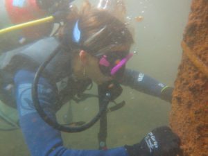
 

CAPTION: Maui Nui Marine Resource Council’s Grace Silver helps to prepare a site in Mā’alaea Harbor for the data sensor on loan from PacIOOS.

Hui O Ka Wai Ola Research Report

in /by

Research Report:
Changes in Water Quality During a 12-Hour Period at Two Maui Beaches

This research report was prepared by the Hui O Ka Wai Ola ocean water quality monitoring team. To learn more about this program, please visit huiokawaiola.com.

To better understand how tide change influences water quality, a group of Hui O Ka Wai Ola Team Leaders spent a full day in December 2019 (approximately 12 hours) measuring water quality parameters hourly at Cove Park in South Maui and Hanaka‘ō‘ō Park in West Maui – a deviation from the Hui’s usual practice of monitoring 41 sites once every three weeks only in the morning.

During this one-day study, we measured nutrient levels. We also measure nutrient levels as part of our regular ocean water quality monitoring year-round. Nutrients, including nitrogen and phosphorus, can indicate pollution from wastewater, run-off from agriculture, landscaping and/or golf courses. Once in the ocean, these nutrients can lead to an overgrowth of algae. Algae, particularly invasive species, quickly out-compete corals for sunlight and overrun large tracts of living reef.

Nutrient values can vary a lot over the course of a tide cycle — low nutrient levels at high tide and higher nutrient levels at low tide. Sites with higher nutrient levels acquire these nutrients via ground water that comes into the ocean as underground “springs.”

The fact that there is fresh water coming in from underground springs over the course of a day is shown by the change in salinity readings. This explains the ever-shifting levels that we see from the data we collect once every three weeks at each site.

During our one day experiment we took 4 nutrient samples, with the first sample at high tide and the last sample near low tide. The accompanying chart shows how salinity decreases as the tide goes out and the fresh water from underground springs comes in, while the nitrate levels increase as the amount of fresh water increases.

Our ongoing Hui O Ka Wai Ola water quality sampling program was designed to catch a variety of tide states so that we can understand not only the average level of nutrients but also the range of nutrient levels each site exhibits.


Another interesting observation is that other parameters vary during the day as well — temperature rises as the sun comes up and heats the top layer of water and then starts to decrease as the sun goes down or if clouds come over. During our one-day experiment, temperatures varied over 2 degrees centigrade during the course of the day.

With our ongoing water quality monitoring, we are careful that we measure this parameter at each site at approximately the same time of day every time we sample so that seasonal temperature variations can be distinguished from diurnal variations.

Finally, dissolved oxygen (DO) and pH levels also vary across the course of a day. Dissolved oxygen is needed for aquatic plants and animals to survive. Corals are very sensitive to changes in ocean chemistry, including increased ocean water acidity (which results in a drop in pH levels).

During our 12-hour study, we found that in Cove Park and Hanaka‘ō‘ō Park these diurnal variations are not as obvious because of the influx of fresh ground water as the tide is going out which also affects levels of pH and DO. In general, pH and DO are at their lowest levels just as the sun rises due to the fact that photosynthesis has not been taking place overnight. CO2 levels rise at night as marine organisms respire, taking in oxygen and producing CO2. There is no photosynthesis at night so as CO2 levels rise, the water becomes more acidic and pH levels drop. Dissolved oxygen also drops because of a lack of photosynthesis that generates oxygen as a bi-product. Once the sun begins to rise, photosynthesis begins again, and the pH and DO levels rise.

Please visit again for more reports from the field. Learn more about Hui O Ka Wai Ola at www.huiokawaiola.com.


Unique Community Based Water Quality Testing Program Expands to South Maui

in /by

KIHEI, HI – November 2, 2017 — How clean is the water at your favorite South Maui beach? Starting November 7, a volunteer-based water quality testing program known as Hui O Ka Wai Ola (Association of the Living Waters), will be expanding to test 12 South Maui shoreline locations every two weeks for six months, then every three weeks thereafter. The project will eventually be expanded to test a total of 24 South Maui locations.

The Hui O Ka Wai Ola water quality-testing project is the result of a partnership with Maui Nui Marine Resource Council (MNMRC), The Nature Conservancy, West Maui Ridge to Reef (R2R) Initiative, and University of Hawaii Maui College, working with the State of Hawaii Department of Health (DOH).

“Hui O Ka Wai Ola is the first community-based water quality monitoring program in the state that periodically measures turbidity (a measure of water clarity), and nutrients (such as nitrogen and phosphorous) in near shore ocean waters and makes their data available to the public,” said Dr. Kim Falinski, Marine Science Advisor at The Nature Conservancy.

“Our goal is to support the Department of Health and Maui County efforts to improve coastal water quality so that coral reefs and native fish populations thrive, and our residents and visitors are safe,” said Robin Newbold, Co-founder and Chair of Maui Nui Marine Resource Council.“We want to help identify problem areas, so remedial action may be taken as needed.”

An expansion of Hui O Ka Wai Ola’s West Maui testing
The Hui O Ka Wai Ola water quality testing program began in West Maui in June of 2016, and has been operating and expanding ever since.

“Volunteers and their team leaders currently test a total of 24 West Maui shoreline locations from the Pali to Honolua Bay,” reported Newbold.

“Starting November 7, Hui O Ka Wai Ola water quality testing will be expanded to include 12 sites in South Maui,” said Emily Fielding, The Nature Conservancy’s Maui Marine Program Manager. “Eventually, this will be expanded to 24 South Maui sites.”

The locations of the new South Maui testing sites will be finalized in the next few weeks after they are evaluated for accessibility by the volunteers and other factors. Sites under consideration include ‘Ahihi Kina’u Nature Reserve, Makena Beach State Park, Maluaka Beach, Oneuli (Black Sand Beach), Makena Landing, Kamaole Beach I and III, Kalama Park Beach, Cove Park and Waipuilani Beach.

Powered by volunteers
“A citizen science program like ours would not be possible without an amazing team of volunteers. They are the backbone of Hui O Ka Wai Ola,” noted Sofia de la Sota, South Maui Regional Coordinator and Team Leader.

“More than 20 volunteers have signed up to work at the 12 new South Maui sites. They have completed intensive training and are ready to start water quality testing,” reported de la Sota.

“The volunteers will collect water quality samples according to strict Department of Health (DOH) standards set forth in the Hui’s Quality Assured Program Plan every two weeks for the first six months, then every three weeks after that,” said de la Sota. “They will be testing several water quality parameters in the field: turbidity, salinity, dissolved oxygen, pH and temperature. During every collection period, the volunteers will also collect samples which will be frozen and shipped to the SOEST laboratory on Oahu for nutrient analysis.”

The program will test for nutrients such as nitrogen and phosphorous compounds, which can indicate pollution from wastewater, run-off from agriculture, landscaping and/or golf courses. Too many nutrients in the water can cause an increase in invasive algae (limu), which is damaging to coral reefs. The resulting data will be used to supplement DOH water quality monitoring on Maui and can be viewed at the Hui O Ka Wai Ola website.

“The data resulting from the Hui O Ka Wai Ola program will support the work of Department of Health employee Meghan Dailer, who tests for Enterococcus bacteria,” said de la Sota.

“Due to budget constraints, Dailer is the only Department of Health employee testing water quality for all of Maui,” said Dana Reed, West Maui Regional Coordinator for the Hui O Ka Wai Ola program. “By supplementing her bacteria testing efforts with our nutrient testing, we can better keep a close eye on changing water quality conditions that can harm our coral reefs and human health. We are happy to support DOH and Maui County with this added testing.”

Monitoring the impacts of development and wastewater
“Some of our possible testing sites in South Maui are slated for expanded shoreline development, such as at Maluaka Beach in Makena,” reported de la Sota. “Cove Park, at the center of the wastewater plume coming from the Kihei Wastewater Reclamation Facility, has been flagged for high nutrient levels and turbidity.”

“If we see an issue with increased turbidity or pollution at these sites, we can sound an early warning to initiate measures to address the run-off and pollution as quickly as possible,” noted de la Sota.

In addition to following a regular testing schedule for each of the sites, the program will eventually allow for additional testing during brown water events.

“It is our hope that frequently collecting water quality data will allow for more effective management practices.” said Emily Fielding.

Future funding sought
 
Testing at 18 of the West Maui sites of the Hui O Ka Wai Ola program is currently funded by North Beach West Maui Benefit Fund; testing at the remaining six West Maui sites is currently funded by Napili Bay and Beach Foundation, as well as National Fish and Wildlife Foundation.

“This expansion to South Maui is made possible with generous support from the National Fish and Wildlife Foundation, Maui County Office of Economic Development and community donors,” said Amy Hodges, Programs and Operations Coordinator at MNMRC. “Funding for the laboratory and field equipment and initial start-up costs were provided by National Fish and Wildlife Foundation. The Hawaiian Island Humpback Whale National Marine Sanctuary (NMS) is providing space for storing the water testing equipment.”

The cost of testing at each location is about $3,600 per site per year, which includes analysis and shipping of nutrient samples to the lab on Oahu. Currently, there is funding to continue testing at the South Maui sites for 15 months.

The three nonprofits that lead the project — Maui Nui Marine Resource Council (MNMRC), The Nature Conservancy and West Maui Ridge to Reef Initiative — rely upon public donations and local grants to finance their work.

“We hope that the public will support this valuable effort with donations on behalf of their favorite beaches in South and West Maui,” said Newbold. “We all want clean ocean water, healthy reefs and thriving local fish populations. This project is one way to help achieve these goals.”

“In addition to the millions of dollars in revenue directly and indirectly coming from coral reefs in Hawaii, we have to think of their ecological, cultural and recreational value. If we want future generations to benefit from Hawaii’s marine resources, we must act now to protect this valuable ecosystem,” said Newbold.

To learn more about Hui O Ka Wai Ola and ways you can donate or volunteer, visit www.huiokawaiola.com. You can also look at data that the Hui has collected on this website, and even download the data for yourself.

About Maui Nui Marine Resource Council
A local community-based nonprofit 501(c)(3) organization now celebrating our 10th anniversary, Maui Nui Marine Resource Council is dedicated to restoring clean ocean water, healthy coral reefs and native fish to near shore waters throughout Maui County. We bring the community together to collaborate, learn, work and advocate on behalf of Maui’s coral reef ecosystems. To learn more, visit mauireefs.org.


About West Maui Ridge to Reef (R2R) Initiative

West Maui Ridge to Reef (R2R) Initiative is an all-encompassing approach across multiple agencies and organizations to address adverse impacts to coral reefs in West Maui. The goal of the R2R Initiative is to restore and enhance the health and resiliency of West Maui coral reefs and near-shore waters through the reduction of land-based pollution threats from the summit of Pu`u Kukui to the outer reef.

About The Nature Conservancy

The Nature Conservancy is a global conservation organization dedicated to conserving the lands and waters on which all life depends. Guided by science, we create innovative, on-the-ground solutions to our world’s toughest challenges so that nature and people can thrive together. We are tackling climate change, conserving lands, waters and oceans at an unprecedented scale, providing food and water sustainably and helping make cities more sustainable. Working in 72 countries, we use a collaborative approach that engages local communities, governments, the private sector, and other partners. To learn more, visit www.nature.org or follow @nature_press on Twitter.

###