Posts

Speaker Series: Unlocking the Mysteries of Biodiversity on Hawaiian Coral Reefs

in , , /by

Join us on February 5 as Dr. John Burns of the University of Hawaiʻi at Hilo shares how the Multiscale Environmental Graphical Analysis (MEGA) Lab is using cutting-edge 3D technology to map and study reefs as the organization pursues its goal of mapping 1 million of the world’s best reefs by 2030.

“Less than 20 percent of our oceans have ever been seen and in order to better prepare for a rapidly changing future, we need to know what we have so that we can understand where we need to go,” said Dr. Burns.

MEGA Lab layers their 3D reef reconstructions with an array of environmental data to improve understanding of the biology and ecology of the underwater habitats. This has helped show how coral reefs are changing over time, and how these changes impact associated reef organisms and the services communities depend on.

Map2Adapt aims to map 1 million of the world’s best reefs by 2030 while also training more than 10,000 citizen scientists to better support their communities. “Through Map2Adapt we are able to rapidly identify the state of our reefs, inform conservation restoration efforts, and integrate better management methods across the planet,” said Dr Burns. “Ultimately, our goal is to use innovative technologies to improve our understanding of reef biodiversity and develop techniques to help protect and preserve these ecosystems for future generations.”

MEGA lab also hosts a live streaming camera and a smart buoy to monitor ocean temperatures and coral reef health through a collaboration with UH Hilo and Aqualink off the coast of Kona, Hawaiʻi. The site utilizes infrastructure at the Natural Energy Laboratory of Hawaii Authority (NELHA) and the Fathom Octopus camera to provide 360 panning ability to optimize reef monitoring.


Save your spot, register today!


Meet the Speaker: Dr. John Burns, Associate Professor in Marine Science and Data Science, University of Hawaiʻi at Hilo
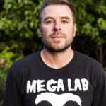
Dr. Burns is a research scientist who studies coral health and disease. His work has investigated the physiological impacts of disease on affected corals and how coral mortality affects the ecology and biology of coral reef ecosystems. John has been continuously searching for both global and localized drivers of coral diseases in order to promote healthy coral ecosystems in the face of global stressors such as climate change. His expertise led to his inclusion in the award-winning documentaries, Chasing Coral, Reefs at Risk, and Island Earth. John has recently developed innovative techniques to create three-dimensional maps of coral reefs to accurately measure how natural and human-induced disturbances impact ecosystem function. John’s research has been presented at scientific conferences around the globe and he has authored multiple publications in international peer-reviewed journals.
 

Speaker Series: Global & Local Coastal Water Quality Data Visualization: A new tool for the Maui community

in , , /by

Join us for a conversation on how Aqualink, a leading platform for real-time oceanographic data, is partnering with water quality monitoring organization Hui O Ka Wai Ola (HOKWO) to empower residents and scientists alike to track water quality and ocean conditions in real-time. Learn about new tools for monitoring sea surface temperature, wind, and wave conditions alongside HOKWO’s essential data on salinity, pH, and turbidity. The partnership aims to highlight the importance of “thinking globally, acting locally,” equipping Maui’s community with insights to safeguard its cherished beaches and reefs. Don’t miss this opportunity to learn more about the global network of ocean advocates and how you can make a meaningful impact in protecting Maui’s coastal waters! Register here:

Save your spot, register today!


Meet the Speaker: Caesar Hjertén, Project Manager at Aqualink
Caesar Hjertén

Caesar joined Aqualink in February 2022 with the goal of advancing the platform and increasing the organization’s impact. Caesar graduated from UH Hilo where he also played for the university’s soccer team. Caesar is passionate about our oceans and the environment. He likes to play sports, dive, surf, and other outdoor activities. At Aqualink, he manages the online platform, fleet of Smart Mooring buoys, and is Aqualink’s primary point of contact.


Meet the Speaker: Liz Yannell, Program Manager at Hui O Ka Wai Ola
Liz YannellLiz joined the Hui as Senior Team Leader in May 2022 and became the Program Manager in June 2023. She has a bachelor’s degree in environmental studies from Florida Gulf Coast University. In 2022, Liz graduated from the Marine Options Program at UH Maui and worked as the assistant in the marine lab on campus. As Program Manager, she is primarily responsible for coordinating various aspects of the program, including field, lab, and logistical support, coordinating fellow team leads, and managing the volunteer program. Her responsibilities include overseeing monitoring operations and data collection, entry, and record-keeping; team lead and volunteer training and coordination; preparing and maintaining supplies and equipment; and meeting with advisory Technical and Steering Committees to ensure successful continuity and growth of the program. She also often joins volunteers in collection and analysis of coastal water samples in the field. Liz is from O’ahu and currently lives in Kula with her two kids and husband. She loves all things ocean-related and is very passionate about coral reef conservation.

Know Your Ocean: Trash Debris Monitoring Reveals Insights into Marine Debris Origins and the Local Community’s Impact on Maui’s Beaches.

in , /by

From December 2022 to January 2023, the Maui Nui Marine Resource Council conducted extensive monitoring and debris removal in six Maui streams and gulches: Ukumehame, Kahana, Kanaio, Kaua‘ula, Wailuku, and an unnamed gulch at Cove Beach Park. The study aimed to establish baseline data for coastal debris sources, assess compliance with the 2022 single-use plastic ban, and raise community awareness about local marine debris. A total of 4,428 trash items were cataloged and removed during 117 surveys, with Kanaio Gulch having the highest trash count. Plastics were the most common type of debris. The study highlights the complex relationship between human activity and marine debris and provides insights into seasonal trends and the importance of community clean-up efforts.

Maui Nui Marine Resource Council invites you to an important FREE Zoom Webinar on Wednesday, October. 4 at 5:30 PM. Find out more about the effort to understand where Maui’s marine debris is coming from and how efforts to reduce it are working… or not. Register here: https://bit.ly/Trash2MarineDebris

Meet the Speaker
Tiara StarkYou’ll meet Tiara Stark, who, growing up on Maui within a Polynesian family, developed a profound admiration for the natural ecosystems of Hawaiʻi, which inspired her to pursue a career in marine conservation. After completing her postgraduate degree, Tiara returned to her island home of Maui to actively contribute to community conservation endeavors. These included part-time positions as a Research Coordinator with MNMRC and as Senior Team Lead with MNMRC’s partnership program Hui O Ka Wai Ola. Tiara is currently Project Manager for The Nature Conservancy’s Maui Marine Program where she leads and supports a range of research and monitoring projects, as well as community-led conservation initiatives all aimed at the shared objective of safeguarding, managing, and revitalizing marine ecosystems for future generations. Tiara’s dedication to marine conservation is also evident in her personal interests, which include snorkeling, scuba diving, and sustainable fishing.
Save your spot, register now: https://bit.ly/Trash2MarineDebris

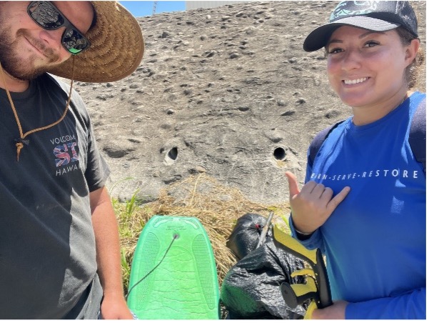
Tiara and Research Assistant, Naha Pierce, remove trash debris from Wailuku Stream.

Tiara and Research Assistant, Naha Pierce, remove trash debris from Wailuku Stream.

Special Event: Mapping Leeward Coral Reefs Before the Impacts of Storm Runoff from the August 2023 Wildfires

in , /by

After the devastating wildfires in Lahaina and Upcountry Maui, the community has been trying to recover from the effects of this unimaginable event. Even as our community is on the mend, a second, disaster slowly approaching the island. The areas burned by the wildfires have been stripped of cover and soils and toxins are poised to wash downstream into our coastal waters and into groundwater. What the effect on our coral reefs, long-term water quality, and resources, such as food fish, will be is uncertain.

Maui Nui Marine Resource Council invites you to an important FREE Zoom webinar on Thursday, Sept. 14 at 6:00 p.m. to find out more about the effort to rapidly map the current, baseline conditions of coral reefs along leeward Maui where the impacts of fire-related runoff are expected to occur. Register here: https://bit.ly/LI_coral_maps

Brett KettleYou’ll meet Dr Brett Kettle of Flying Fish Technologies, who has pioneered coral reef protection for over three decades, both on the Great Barrier Reef (GBR) and internationally. Brett began to prototype his long-term vision for a high-speed, broad-scale underwater visual survey tool in 2017. His vision was to document more of the Great Barrier Reef than had ever been documented before and to use emerging technologies like AI/ML to accelerate the analysis of collected data. The result is the Vertigo3 glider, a towed ROV that can survey 10ha (25 acres) an hour while recording over 50,000 high-resolution images.
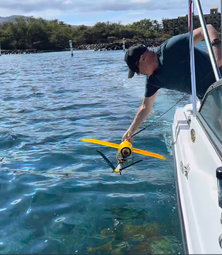
During the webinar, you’ll be introduced to how Vertigo3 functions and how it is being used to image extensive sections of Maui’s leeward reefs. These images will allow comparison of the current state of coral reefs that may already have been impacted with unaffected “control” regions and will allow accurate assessment of any effects when storms deliver runoff to our precious nearshore reefs. The technology also opens up a remarkable set of opportunities to view and study Maui’s reefs from above the water in ways that were impossible until now.

Save your seat for the Webinar: https://bit.ly/LI_coral_maps

Brett deploys the Vertigo3 Glider off of the Kihei Boat Ramp in Maui, Hawaii

Brett deploys the Vertigo3 Glider off of the Kihei Boat Ramp in Maui, Hawaii. Photo: John Starmer, MNMRC.

Know Your Ocean: Making use of Natural Sounds Underwater.

in , /by

Dr. Simon Freeman, Program Director at the Advanced Research Projects Agency-Energy (ARPA‑E), presented “Signals in noise: Adventures in using natural sounds underwater.” at our June Know Your Ocean speaker series event.  He gave an overview of some of the work his group has performed over the years, focusing on situations where they were able to find helpful information contained in natural ocean soundscapes including those produced by coral reef ecosystems. He then discussed what could happen in the future using natural underwater sounds to quantify carbon capture in the ocean as part of his efforts in working for the Department of Energy. Simply click on the video below to watch the presentation.

Public invited to free webinar on “Shark Research in Hawaii – With an Emphasis on Maui” by Dr. Kim Holland on Wednesday, March 3

in /by

KIHEI, HI – Recent shark attacks that occurred off the coast of Maui in November (2020), December (2020) and January (2021), as well as an incident in February (2021) which involved a large shark biting a kayak, have many ocean users concerned and curious about the sharks found in our nearshore waters. The public is invited to learn more about our local sharks at a free Zoom presentation titled “Shark Research in Hawaii – With an Emphasis on Maui’ by Dr. Kim Holland. Dr. Holland is the Research Professor at the Hawaii Institute of Marine Biology, (HIMB) at University of Hawaii at Manoa and the founder of the Shark Research Group at HIMB.

This free talk is hosted by Maui Nui Marine Resource Council’s “Know Your Ocean Speaker Series” and will take place on Wednesday, March 3 at 5:30 pm via Zoom. The presentation is free, but advance reservations are required. To reserve your spot, please visit https://bit.ly/SharkWebinar

For over 40 years Dr. Holland’s research has focused on the biology and movement patterns of large marine fishes such as tuna, billfishes and sharks. He has been a pioneer in helping to develop and deploy cutting edge tracking technologies that allow unprecedented insight into the movement patterns of marine fishes.
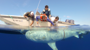
His presentation will include a brief overview of tracking technologies with an emphasis on what has been learned about the movements of sharks around Maui Nui.

“While many Maui residents and visitors are fearful about sharks, it’s important to remember that sharks play an important role in maintaining Hawaii’s ocean ecosystems,” said Anne Rillero, Communications, Community Outreach and Development Manager at Maui Nui Marine Resource Council. “We’re looking forward to learning more about Dr. Holland’s findings and insights about Hawaii’s sharks.”

Maui Nui Marine Resource Council’s “Know Your Ocean Speaker Series” events are held monthly via Zoom. Support for these events is provided by the County of Maui Mayor’s Office of Economic Development.

The emcee for this event is Darla Palmer-Ellingson, local radio show host of the public affairs program, Island Environment 360 Maui’s only commercially broadcast public affairs show on environmental and related Hawaiian cultural topics, aired on the stations of H-Hawaii Media.

To reserve your spot at this free Zoom webinar, please visit https://bit.ly/SharkWebinar


Experts tag a tiger shark with a tracking device in the waters off Maui. The satellite tag gets attached to the shark’s dorsal fin and sends a signal every time the fin surfaces the water. Photo Credit: HIMB