Tracking reef health in Lāhainā one year post-fire
One year after the fire, the Maui Nui Marine Resource Council (MNMRC) partnered again with Flying Fish Technologies (FFT) to resurvey reef sites the team visited in 2023.
During the height of the 2023-2024 rainy season, heavy January rains washed significant amounts of toxic runoff into the ocean. Resurveying key sites after the rainy season was critical to understanding how this runoff impacted nearby reefs and fish populations.
As more time passes, it becomes difficult to distinguish recently dead coral from coral that has been dead for some time and to identify the cause. While our survey coverage only addressed some of the deeper (~10 m) areas, the initial results suggest little has changed since 2023.
An important note is that runoff from the fire was concentrated in shallower areas, closer to shore, and MNMRC is working to bring FFT back to revisit those sites (~ 3 m).
West Maui Coral Reef Surveys 2023-2024
July 2025: Early Lāhainā Reef Health Results
The results of both 2023 and 2024 surveys are presented as site-specific “posters” that describe the conditions at selected sites. When possible, 2023 and 2024 data are shown together.
In other cases, the results of deep and shallow analyses from 2023 are paired together. For a few sites, where deeper areas were only sand, only the results from the shallow survey are shown.
At present, coral populations at key sites should either be recovering from the negative effects of the runoff events, or the coral may be showing signs of stress or have died. By comparing survey data and 3D maps, MNMRC can evaluate how the reef sites have changed due to the fire and, by extension, better understand how to protect the reef against further damage.
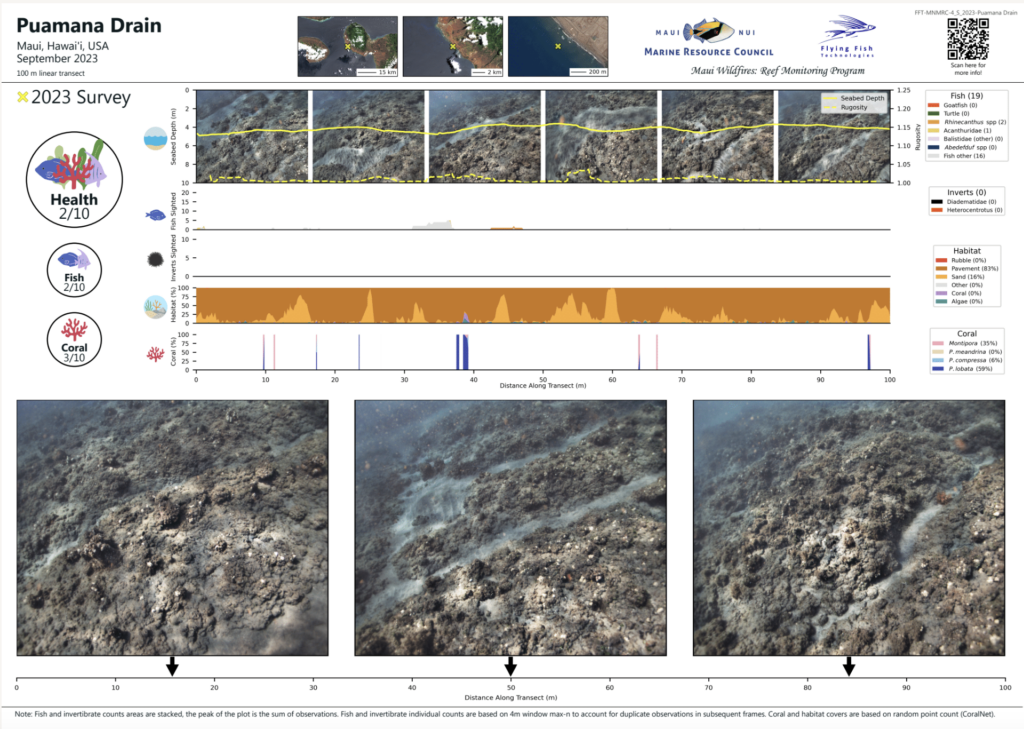
Posters illustrating reef health near the burn zone were created from surveys done in 2023 and 2024 by the Maui Nui Marine Resource Council and Flying Fish Technologies.
No precedent exists for an urban wildfire event occurring so close to a reef, and there is no easy way to predict how the fire’s aftermath may impact overall reef health and the fragile ecosystems along the coastline and near-shore waters. Continuing this important work provides a way to study, compare, and note changes at the affected sites and detect changes in coral cover and fish/invertebrate abundance.
Findings can then be used to create actionable solutions to protect and restore impacted marine ecosystems. MNMRC is committed to sharing research findings with the Maui Nui community as we continue to work together to care for and protect our fragile coral reefs and support Lāhainā’s near-shore ecosystem.
Our Science Director, John, shares insight from these early results in the video below.
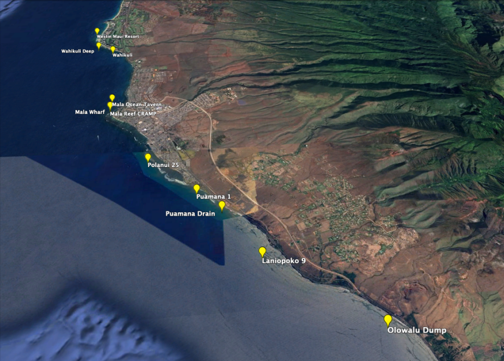
Click the links to view individual site posters
Westin Maui
Wahikuli Deep
Wahikuli
Mala Ocean Tavern
Mala Wharf
Mala Reef CRAMP
Polanui 25
Puamana 1
Puamana Drain
Launiupoko 9
Olowalu Dump
MNMRC’s 2023 Wildfire Response
Following the devastating Lahaina wildfire, Maui Nui Marine Resource Council (MNMRC) launched a phased project in 2023 to study and monitor the fire’s impact on reef health near the burn zone. The project aimed to use 3D imaging technology to map and assess key reef sites, capturing “snapshots” before and after rainy season runoff. Rainy season, which typically runs from November – March on Maui, was expected to result in heavy storm runoff that would wash debris, toxins and other waste from the fire into the ocean.
September 2023: Assessing Lāhainā’s Reefs
Just a few weeks after the devastating wildfire and well before major runoff entered nearby waters, the Maui Nui Marine Resource Council (MNMRC) collaborated with Australian start-up Flying Fish Technologies (FFT) to take 800,000 images of priority reef sites, which were then used to generate 3D maps.
“The cutting-edge technology offered by Flying Fish allowed us to collect information about reefs in South and West Maui more quickly, safely, and cost-effectively across more reef area than by using the traditional approach of diver surveys,” said John Starmer, Science Director at MNMRC.
Flying Fish also trained and applied a machine-learning algorithm to the underwater footage to count and identify coral and fish species around Lāhainā. When a diverse mix of corals and fish are found in enough numbers, it almost always means a reef is healthy but when the numbers and diversity are low, the opposite can be expected. Scientists can use this new algorithm to study reef health over time to determine whether action is needed to help a struggling reef recover.
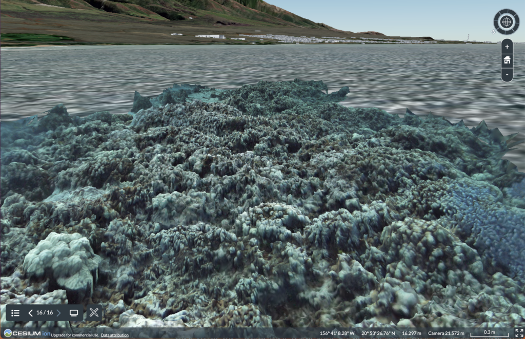
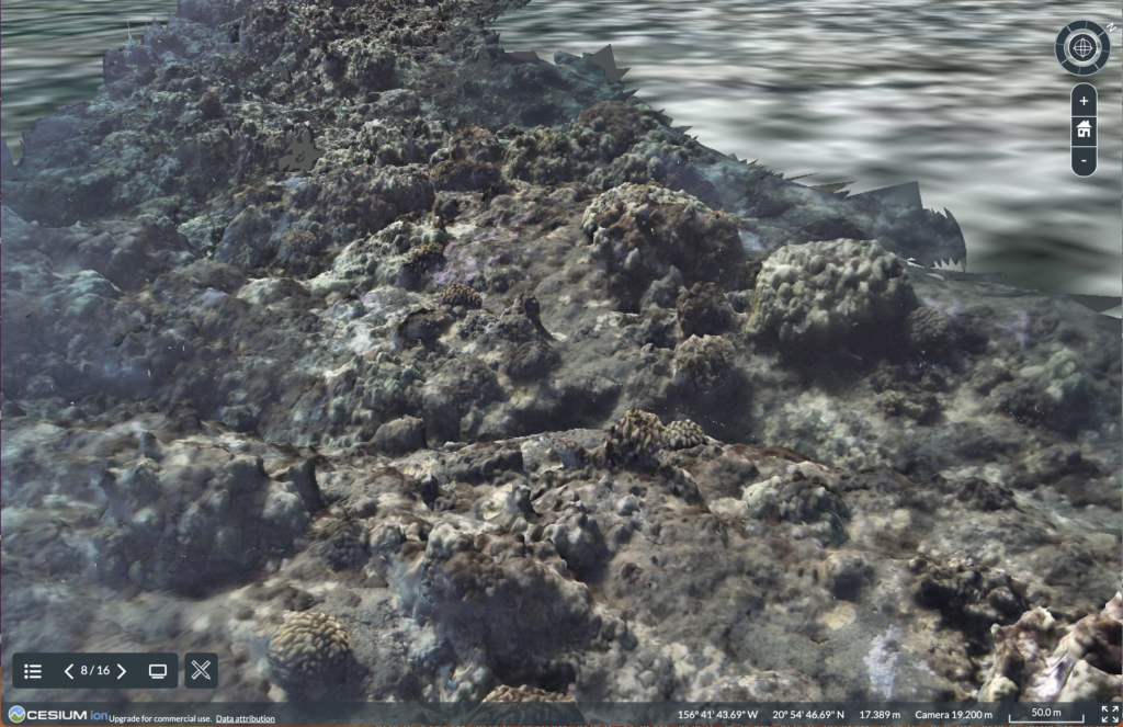
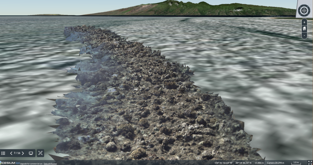
3D map of reefs in Lahaina before toxic debris, runoff, and other waste from the fire washed into the ocean. (Photo Credit: Flying Fish Technologies)
A machine-learning algorithm analyzes underwater drone footage of a reef site. (Video Credit: Flying Fish Technologies)